La scoperta dell’acqua fredda
The Roman Thermal Baths of Mezzomiglio in Chianciano Terme between old excavations and new data
Marco Pacifici
Abstract
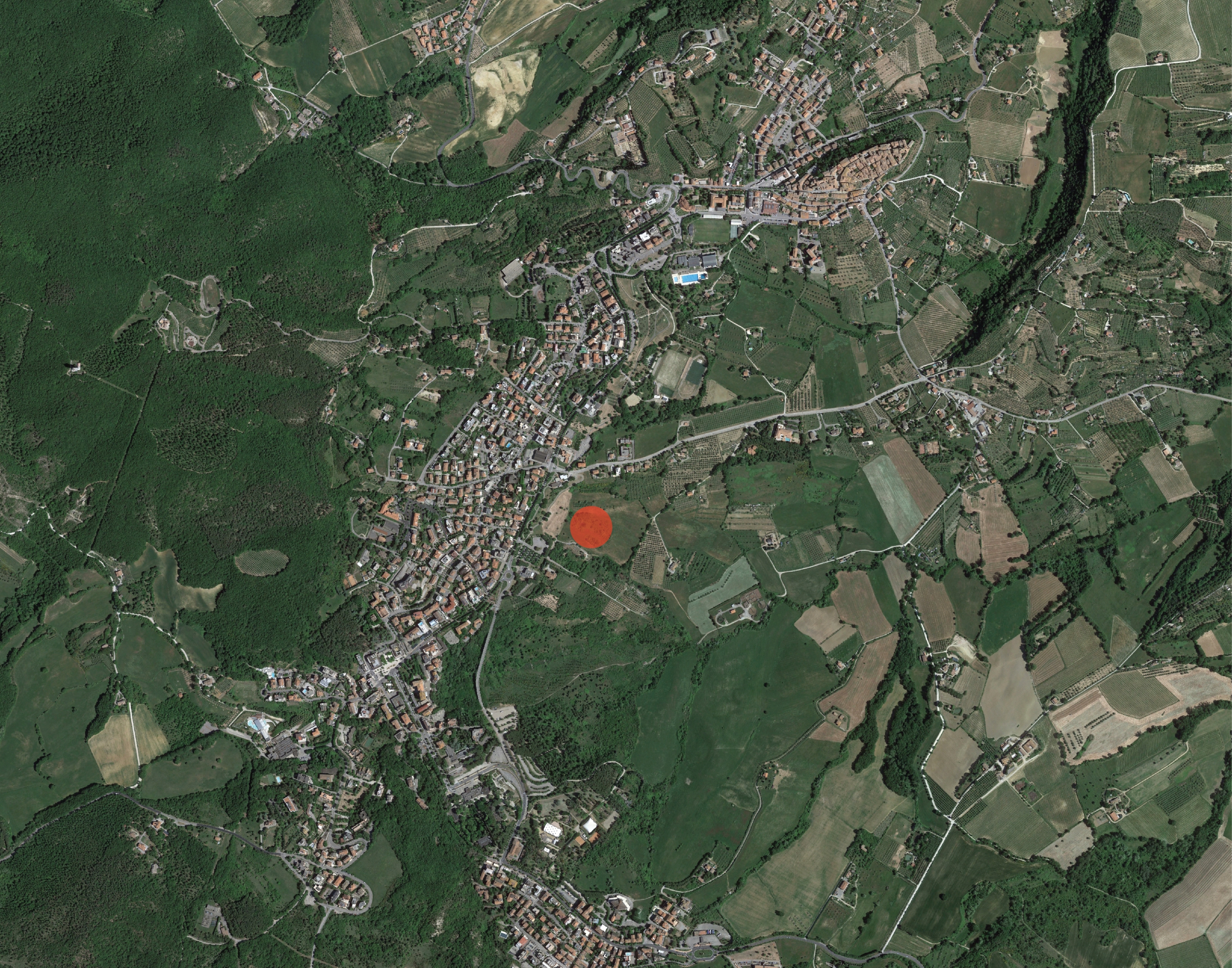
1 | Satellite photo of Chianciano Terme with the area of Mezzomiglio (photo by Google Earth).
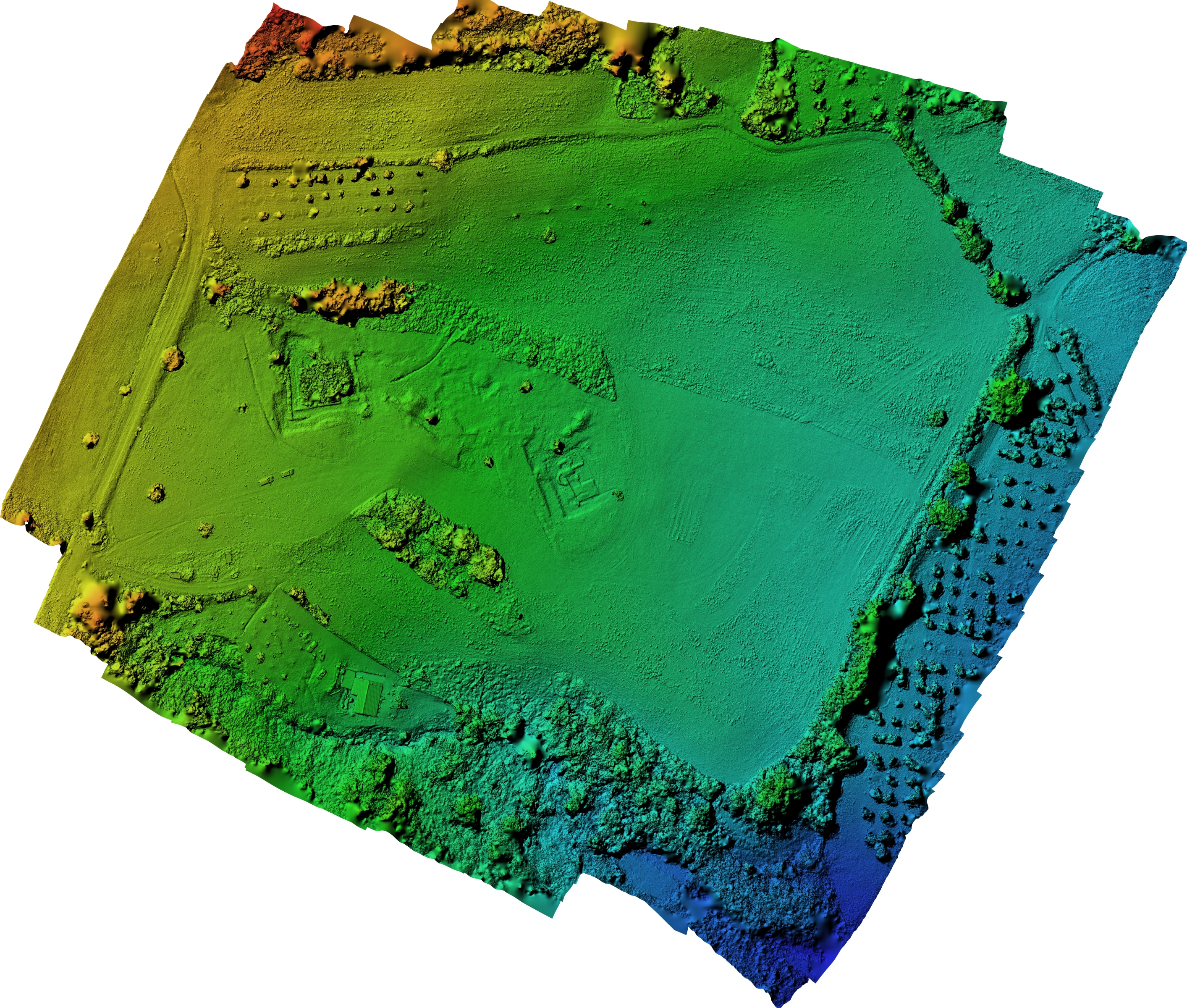
2 | Digital Elevation Model (DEM) of the Mezzomiglio area (ATS S.r.l.).
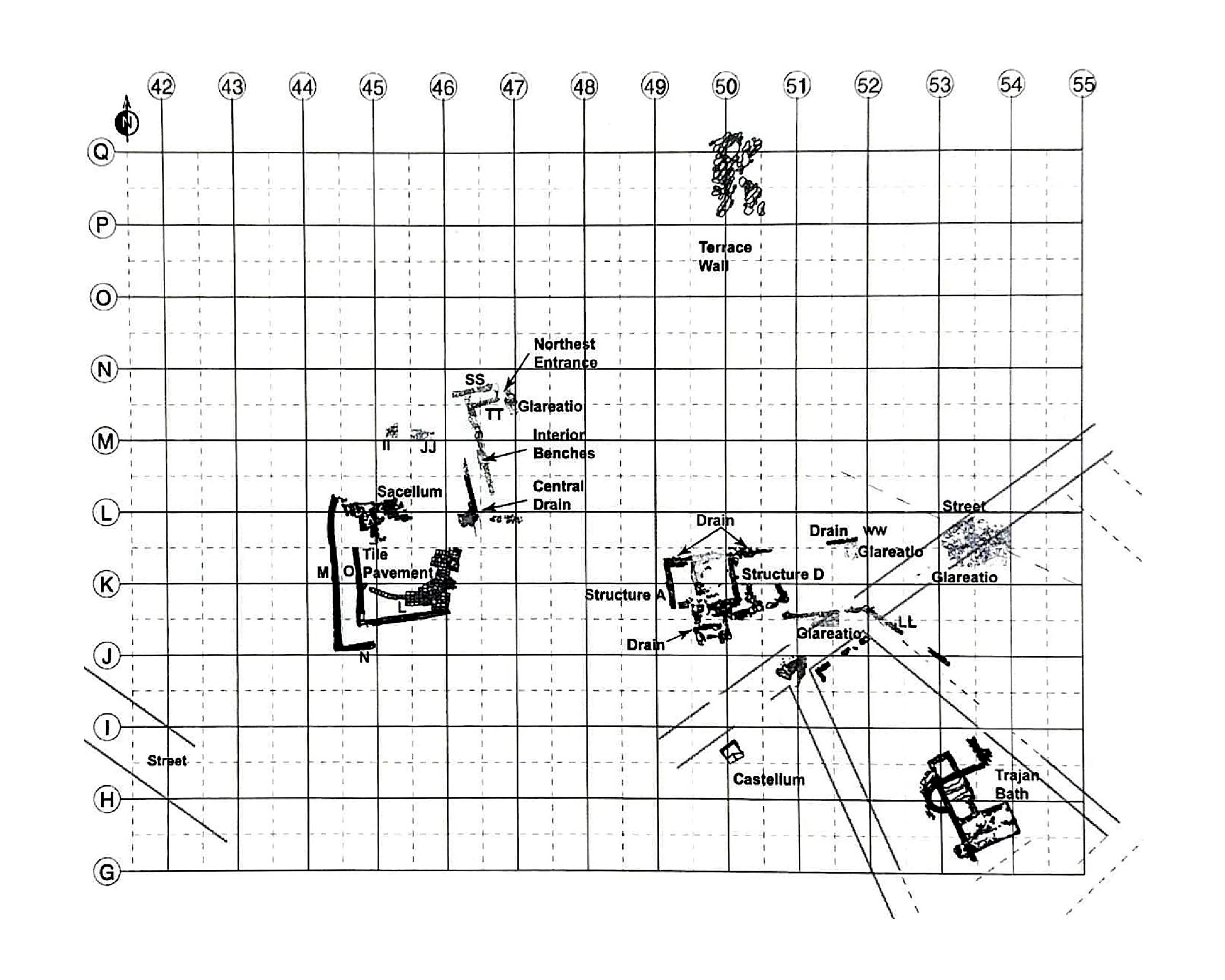
3 | Plan of Mezzomiglio site (after Mecchia, Soren 2010).
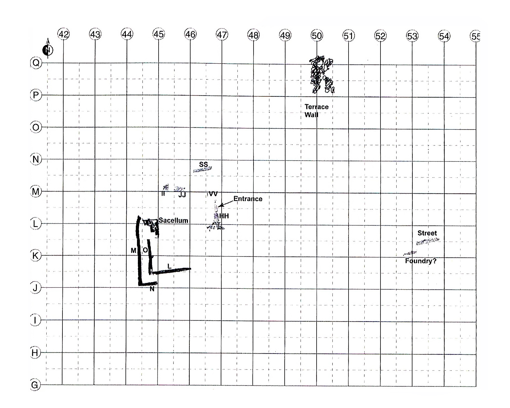
4 | Plan of Mezzomiglio site in Phase 1 (after Mecchia, Soren 2010).
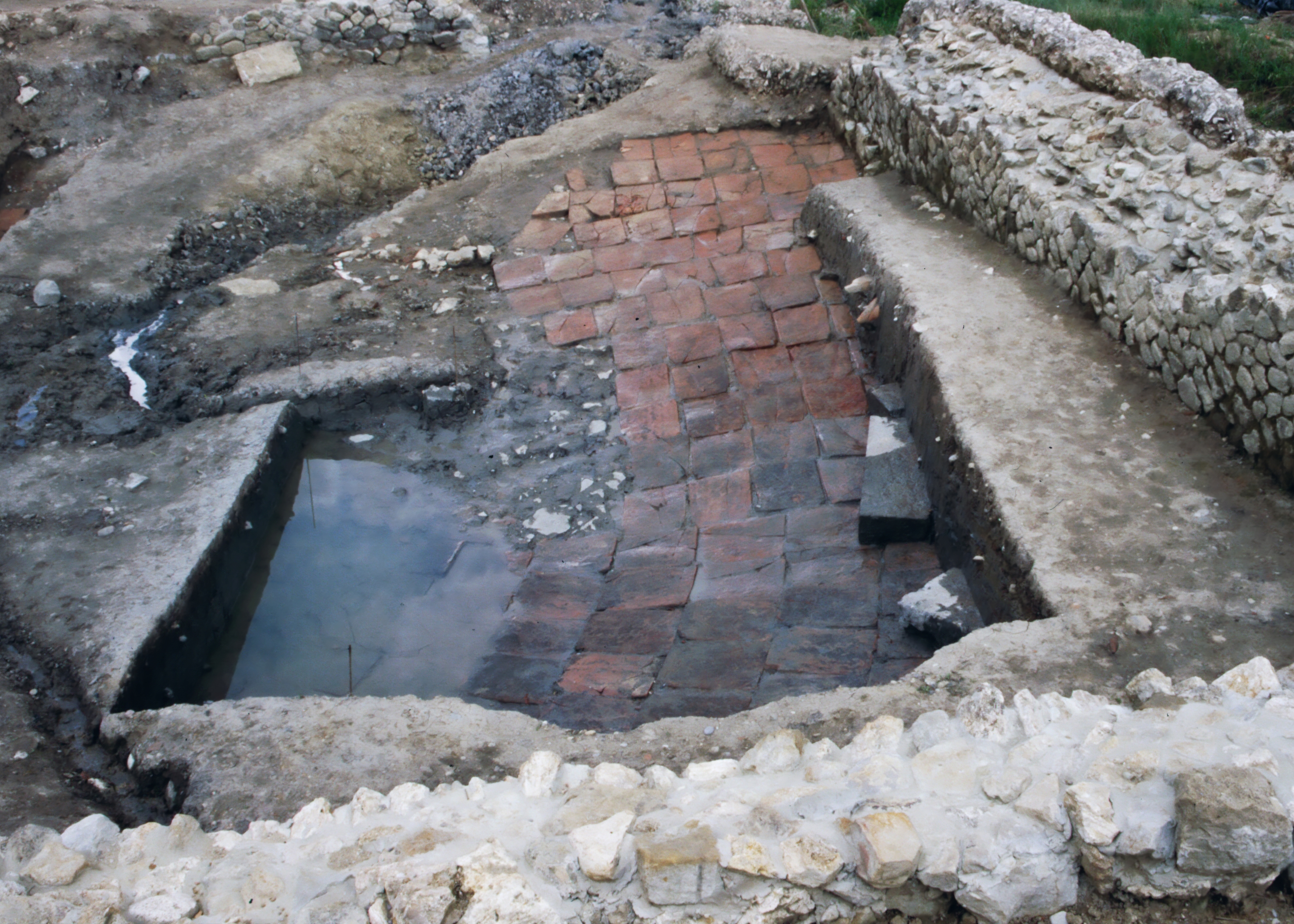
5 | Image of the vasca, with the floor made of embrici, being excavated (N. Soren photo).
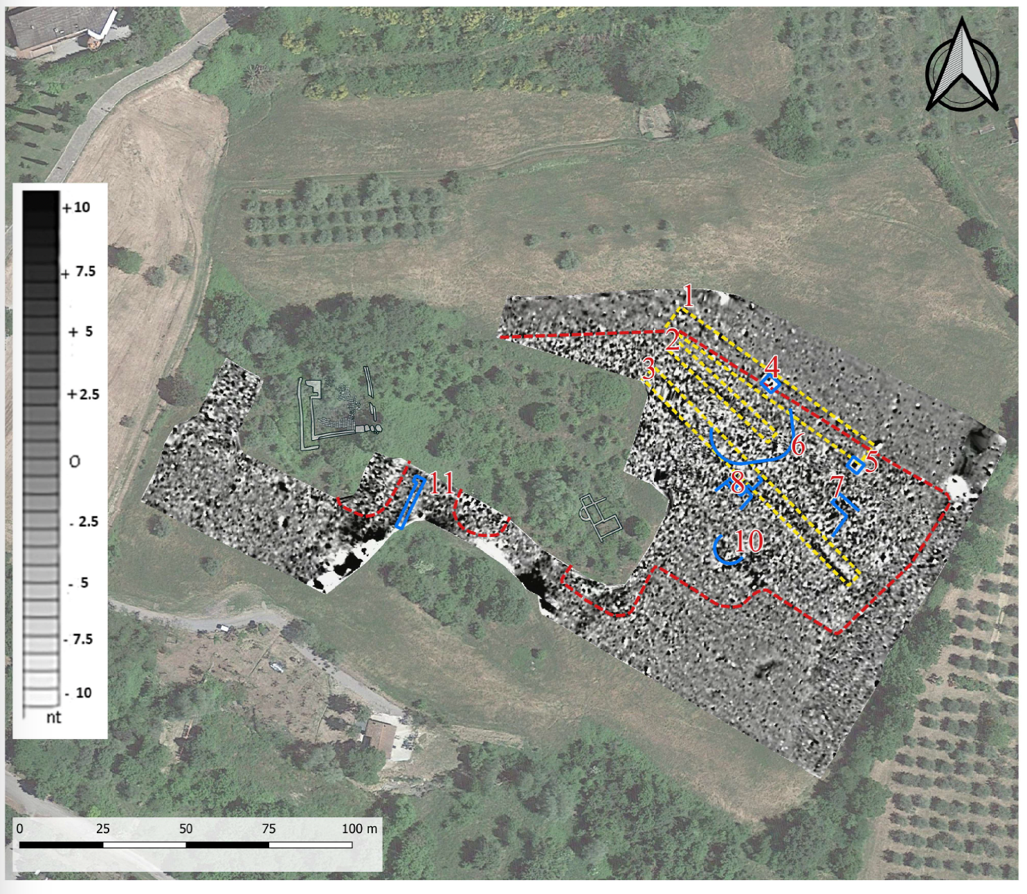
6 | Map with magnetometric survey and interpretations (ATS S.r.l.).
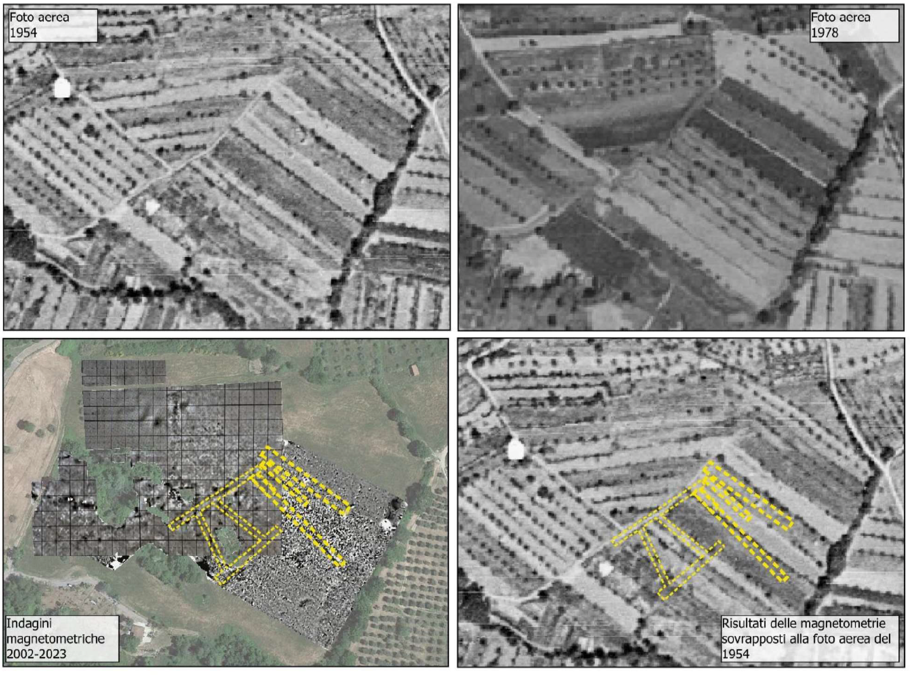
7 | Above: aerial photographs from 1954 and 1978 kept at the Tuscany Aerophoto Archive. Bottom left: map with reconstruction of the road routes identified through the geophysical surveys carried out in 2001 and 2023. Bottom right: road routes overlapped on the 1954 aerial image (ATS S.r.l.).
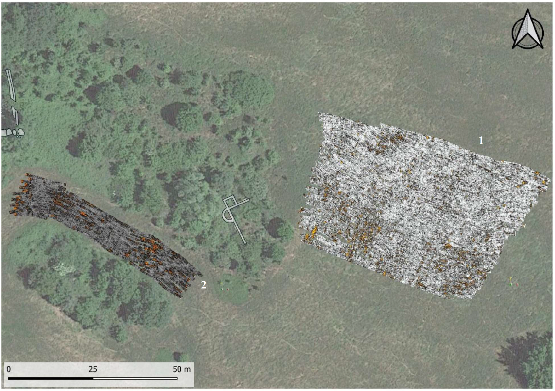
8 | Georadar survey map 40 cm deep (ATS S.r.l.).
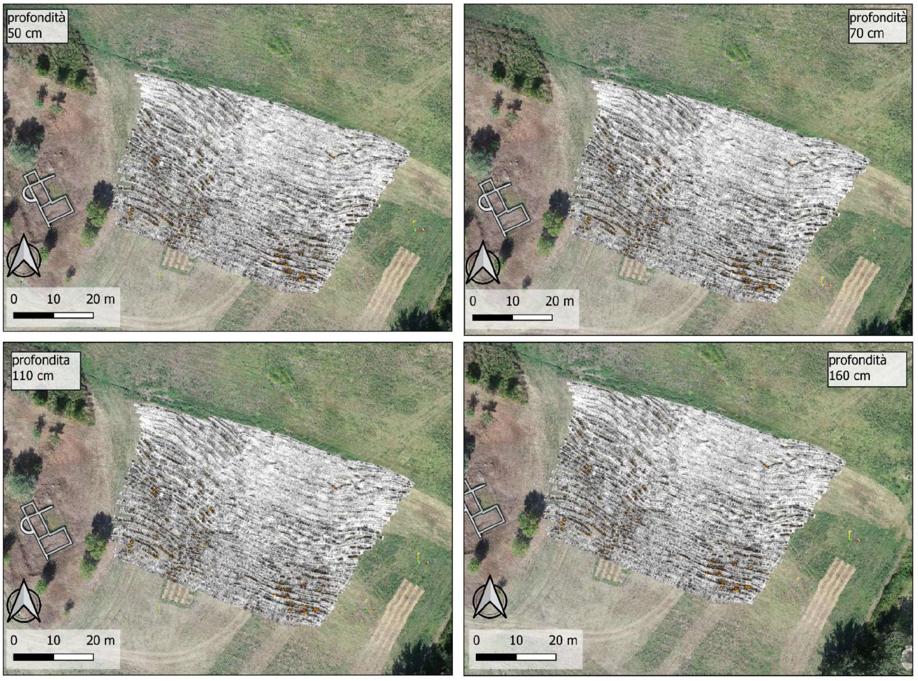
9 | Georadar map of Area 1 at different depths (ATS S.r.l.).
Within the territory of the municipality of Chianciano Terme (SI), the toponym Mezzomiglio relates to an area located respectively south and east of the modern Via della Valle and Viale della Libertà [Fig. 1] (Paolucci 2007, 92). This is a roughly flat, gently sloping portion of land which follows a regular northwest-southeast direction. Archaeological excavations at this site have uncovered an articulated complex of structures with thermal function, mainly dating from the Roman period [Fig. 2]. Remains of masonry from this period were already reported in this area by local scholars during the 18th century (Paolucci 2007, 92). Afterwards, a marble block inscribed was found during the demolition of a building near the northern boundary of Mezzomiglio in the early 20th century. A text relating to the equestrian career of a tribunus militum, whose cognomen we know as Laronianus, was carved on it. Oral evidence also attested to re-used travertine blocks recovered in all probability from the nearby thermal baths (Paolucci 1997, 91).
The first excavations in the locality of Mezzomiglio, some test trenches, were carried out by the local Associazione Geo-Archeologica di Chianciano Terme in 1988 and 1989. More substantial explorations in 1993 and 1994 under the direction of G. Paolucci took place (Soren 2006, 315). Systematic excavation campaigns finally started in 1995 under the direction of Prof. D. Soren (University of Arizona) and lasted until 2001, with a brief resumption between 2003 and 2006. Through the excavation, the American team was able to bring to light large portions of the site and to propose a chronological reconstruction divided - in its most updated version - into ten phases, ranging from the earliest data, which can be dated to the 3rd-2nd century BC, to the modern period (Soren in Mecchia, Soren 2010, 183).
It is not my intention to retrace in detail the history of the site, which was deeply presented by the excavators in the publication of the results of their investigations in 2006 and 2010 (Soren 2006; Mecchia, Soren 2010). However, I would like to briefly review the main stages of its development.
The oldest evidence identified (Soren, Bizzarri, Marzano, Olivas in Soren 2006, 316-324, phase 1; Soren in Mecchia, Soren 2010, 183-185, phase 1) is a collapsed polygonal structure made of large sandstone blocks at least 10 courses high, which was identified near the northern boundary of the Mezzomiglio area and generically dated by the discoverers to between the 4th and 2nd centuries BC [Fig. 3] (Marzano in Soren 2006, 355-357). Even the water basin, the so-called vasca in which it was possible to immerse oneself, hypothetically 21 m wide and 36-38 m long, and seen as the centre of the bath site, was already present at least from some unspecified time in the 2nd century BC, as evidenced by several fragments of opus incertum. These are the oldest masonry identified, which emerged in the eastern portion of the building in some test trenches carried out between 2003 and 2006 [Fig. 3]. The structure was characterized by a central quadrangular pool for immersion, most probably bordered on all four sides by columned corridors that ran all around the structure. The structure was possibly accessible on the east side, while on the west of the vasca a podium with a niche, a small sacellum according to the interpretation of the discoverers, was found. In their view, the sacellum could have housed a statue to which a marble fragment representing the portion of a horse’s leg in two-thirds lifesize, found during the excavations, might belong (Soren, Bizzarri, Marzano, Olivas in Soren 2006, 321).
The pool was fed by a spring of water that still gushes out in its original location near the structure, even though the changes that took place in the area over the centuries, culminating in the intense building development of the 20th century, have led to a decrease in the flow rate and mixing of the resurgent water with the sewage from some malfunctioning systems (in 2023 a remedy for the contamination of the spring was found). The water has a temperature of 15°C approximately constant throughout the year and high concentrations of sulphates, carbonates, and calcium (Artiola in Soren 2006, 290-293). In the area, at approximately 87 m northeast of the first spring, a second one, also characterised by high concentrations of compounds and a roughly similar temperature (15.9°C) is also attested (Artiola in Soren 2006, 292).
The high concentrations of substances in the water make it unsuitable for drinking except for very short periods (Artiola in Soren 2006, 292). However, the temperature of the two springs and their properties have led to the hypothesis that the site is associated with the locality in the territory of Chiusi where the poet Horace is said to have practised the cold-bath therapy prescribed for him by the physician Antonio Musa (Hor. ep. 1.15.2-9). He was a freedman and personal physician to the emperor Augustus, whose life he had saved with this practice, which consequently found great affirmation and wide application between the end of the 1st century BC and the 2nd century AD (Romer, Soren in Soren 2006, 295-297). Although the evidence for a specific dating is rather scarce, it seems that a stone paved road identified to the east of the vasca can also be assigned to this older phase. Immediately to the south of this road, a particular concentration of iron slags has also made it possible to assume the coeval presence of a foundry [Fig. 4] (Soren in Mecchia, Soren 2010, 184).
During the 1st century BC (Soren, Bizzarri, Marzano, Olivas in Soren 2006, 324-329, phase 2; Soren in Mecchia, Soren 2010, 185, phases 2 and 3), the unstable ground conditions in the area where the large pool structure stands required continuous rebuilding and maintenance of the building, which was first carried out in opus incertum and then in opus reticulatum. Moreover, it was during this phase that the podium structure along the western edge of the vasca assumed its final form [Fig. 3]. In Trajan's time (Soren, Bizzarri, Marzano, Olivas in Soren 2006, 329-331, phase 3; Soren in Mecchia, Soren 2010, 185-187, phase 4), the site underwent a radical change and there was a probable development of the area in an ‘urban’ sense. The vasca structure underwent major reconstruction work on the walls and the use of lead piping for water management, as well as a floor made of inverted embrici laid on the clay bottom of the basin, 39 of which are characterised by the VOPETHASTCOS (Vopisco et Hasta consulibus) stamp, attested in Chianciano and Chiusi, which provides a date of 114 AD [Fig. 5] (Romer in Soren 2006, 354). Moreover, in this period to the southeast of the site, a small thermal complex of the type with frigidarium, tepidarium, and calidarium was built, its water supply ensured by a castellum aquae constructed to the northwest, which regulated the abduction of water from the spring using lead pipes. In the vicinity of this bath, also thanks to the data that emerged from geophysical survey, a system of four roadways that surrounded the structure may have been articulated. One of these, the one with a northeast-southwest orientation, represented a section of a wider and longer roadway that was perhaps one of the site's main paths [Fig. 3]. In the central portion of the investigated Mezzomiglio area, between the vasca and the road that bounds the area of the small bath to the northwest, some mudbrick and half-timbered buildings on stone foundations have been constructed, or perhaps renovated as they were built during the previous phase, whose function, however, cannot be convincingly hypothesised at the current state of knowledge [Fig. 3].
In the 3rd century AD, perhaps as early as the end of the previous one (Soren, Bizzarri, Marzano, Olivas in Soren 2006, 331-332, phase 4; Soren in Mecchia, Soren 2010, 187, phase 5), the beginning of the decline of the site can be recognised. No substantial changes to the structures are attested, but only partial refurbishments of mediocre quality, aimed at maintaining the functionality of the facilities as far as possible.
During the 4th century AD (Soren, Bizzarri, Marzano, Olivas in Soren 2006, 332-336, phase 5; Soren in Mecchia, Soren 2010, 187, phase 6), the vasca was no longer in use, as witnessed by the interruption of its use for bathing purposes, as indicated by the collapse of part of the colonnade and by the filling of the basin with sand and clay. A coin found in the collapse levels of the pool structures, dated between 335 and 341 AD, provides a firm chronological indication. The structures located in the central area of the site, in this phase already in a state of abandonment, were instead destroyed towards the end of the century by a possibly intentional fire, hypothetically connected to the final disposal. At the end of the 4th century AD, probably around 380 (Soren, Bizzarri, Marzano, Olivas in Soren 2006, 336-338, phase 6; Soren in Mecchia, Soren 2010, 187, phase 7), the perimeter masonry of the vasca, which was probably in a serious state of disrepair, was reinforced with conglomerate walls and the building was used as a drinking trough for animals. Near the podium, a small basin was created with tiles placed at a 45° angle and only the central portion of the structure was kept clear to ensure access for the animals. Above the structures destroyed by fire in the previous phase, a small pool was also built, perhaps to construct a small new bath, using the same spring that had supplied the main vasca.
During the 5th century AD, the area of Mezzomiglio was definitely abandoned and only occasionally frequented (Soren, Bizzarri, Marzano, Olivas in Soren 2006, 338-340, phase 7; Soren in Mecchia, Soren 2010, 187-188, phase 8). The last evidence of the use of the area to access the spring water is to be dated to the Middle Ages when a well was built to the west of the pool structure for this purpose. The brief and concise analysis of the life phases of Mezzomiglio as reconstructed by the discoverers testifies that the site is one of the main Roman baths in the area (Paolucci 2007, 189) and probably represents the bath complex, or one of the complexes, in the territory of Chiusi renowned for its cold hydrotherapy, particularly practised between the Augustan age and the 2nd century AD.
To enhance the site through a better knowledge of its various aspects and its inclusion in the cultural offerings of the territory, to overcome the crisis of the thermal spa mono-economy that has affected the territory in particular over the last fifteen years, in 2021 the Municipal Administration of Chianciano Terme acquired ownership of the cadastral parcels, which have always been private property, within which the archaeological site falls. The Municipal Administration also decided to participate in the financing of a Postdoctoral Fellowship at the Università per Stranieri di Siena with a project entitled ‘Ancient Thermal Baths between the Etruscans and the Romans: Investigating the Site of Mezzomiglio at Chianciano Terme (SI) between Archaeology and Economy of Culture’, starting from 1st October 2022, and refinanced for a second year, to deepen the knowledge of the thermal site and plan its inclusion within the tourist-cultural proposal of the municipal territory.
In the context of this assignment, an ongoing complete re-examination began of the considerable amount of documentation and archaeological material recovered during the excavations conducted by the University of Arizona at Mezzomiglio, as well as ex novo investigations to understand the original extent of the site and thoroughly investigate its internal articulation. In 2023, a geophysical survey was carried out in the area of Mezzomiglio owned by the municipality, to collect new data and verify those obtained through the use of non-invasive survey methodologies by the American team at the same time as the excavation campaign. The area, in fact, had already been surveyed in 2001 through three methodologies – electrical resistivity, magnetic field gradient, and GPR – which allowed the researchers to identify elements pertinent to the area's urbanistic layout (Jones, Maki, Soren in Soren 2006, 307-309). The new investigations, authorised by the Soprintendenza Archeologia, Belle Arti e Paesaggio per le province di Siena, Arezzo e Grosseto, embodied by the archaeology officer in charge for the territory of the Municipality of Chianciano Terme, Dr Ada Salvi, were carried out by the specialists of ATS S.r.l. - I would like to take this opportunity to express my sincere thanks to Ada Salvi, Francesco Pericci and Cesare Felici - and provided for the realisation, on areas of interest identified thanks to the analysis of the data already available and through examination in the field, of magnetometric and georadar surveys, as well as a photogrammetric survey of the entire area (approximately 7.5 hectares) with the relative elaboration of a high-resolution digital elevation model (DEM).
The magnetometer survey was carried out on an irregular shape area covering approximately 3 hectares to the northeast, east, and south of the complex of thermal structures unearthed by the American excavations. The surveys were carried out using a Foester Ferex magnetometer that employs fluxgate sensors, usable in different configurations. In particular, the exploration was carried out in cart mode (cart with 4 sensors spaced 50 cm apart). The resolution is also quite high thanks to each sensor’s acquisition of a point every 10 cm on the walking axis. The system is integrated with a GPS with centimetric correction, which made it possible to have all the grids georeferenced. The acquisition was carried out on 3rd May 2023 in the absence of obstacles on the ground, following the cutting of the vegetation by the municipality’s staff, which was a perfect condition for the continuous acquisition of the data. The analysis of the magnetic data (the processing was carried out with values between +/- 10 nt) made it possible to identify and delineate quite precisely the perimeter of the area corresponding to the archaeological deposit that characterises the locality of Mezzomiglio [Fig. 6, area delimited by red dotted line]. The presence of archaeological material below ground level was in fact returned by the tool with a particular concentration of dipoles that disappear outside the limits of the area.
The interpretative analysis of the data also highlighted the presence of eleven specific anomalies characterised by dipoles, or clusters of dipoles, mainly concentrated in the eastern zone of the area under investigation, while it was possible to identify a single trace not far from the east of the large quadrangular vasca. Within the area delimited by the red dotted line, the presence of at least six dipoles, possible archaeological evidence, can be observed [Fig. 6, nos. 4, 5, 6, 7, 8 and 10]. In particular, two of these dipoles, nos. 4 and 5 [Fig. 6], show magnetic values compatible with strong exposure to heat, a circumstance that could suggest the presence of possible production contexts, perhaps furnaces, in the two points, a fact that seems compatible with what already emerged during the excavations.
Traces nos. 7, 8, and 10 [Fig. 6], on the other hand, present themselves as anomalies of a linear type, with an orientation roughly parallel to that of the small-scale bath building from the Trajanic period that emerged during the excavations. These are most likely buried wall structures. The analysis of anomaly no. 6, on the other hand, is more complex, with an irregular roughly ovoid shape, which would seem to have an orientation and structure inconsistent with that of the other identified anomalies. At present, it does not appear possible to make any convincing interpretations.
Dipole no. 11 [Fig. 6], located to the southeast of the large quadrangular vasca, appears as a linear anomaly that extends southwest-northeast for approximately 14 m and then terminates with a section that forms a right angle as it continues northwest; the thickness of the anomaly is regular and measures approximately 2 m. Even in this case, the interpretation of the trace presents non-negligible problems. Although it could hypothetically be associated with the large quadrangular vasca to the northwest, it is located a short distance from some modern concrete structures of a wastewater disposal system that is currently disused, located a short distance to the southeast within an area that is now fenced off and scrubby, a circumstance that leaves particularly significant doubts as to its interpretation (for modern period of use of the Mezzomiglio area, see Soren, Bizzarri, Marzano, Olivas in Soren 2006, 340-344, phase 9; Soren in Mecchia, Soren 2010, 188, phase 10).
Lastly, dipoles nos. 1, 2, and 3 [Fig. 6], identified to the northeast of the area under investigation, appear as three rectilinear anomalies roughly parallel to each other with a southeast-northwest trend and a length of between 40 and 80 m. The overlapping of these results obtained with aerial photographs of the area taken in 1954 and 1978, which are kept at the Aerofototeca della Regione Toscana, has shown that these anomalies can at least in part be related to the modern agricultural land divisions or perhaps to inter-country road routes [Fig. 7], while only in the case of anomaly no. 3 could hypothetically be a road section approximately perpendicular to the main one with a northeast-southwest trend identified during the American investigations.
Unfortunately, as the results of the geophysical survey carried out in 2001 were not available in digital form, an attempt was made to georeference the results with the highest possible degree of accuracy. By comparing these data with the aforementioned 1954 and 1978 aerial images, it is evident that some anomalies, in particular the road layout with a northwest-southeast orientation located to the northeast of the 'block' within the small Trajan bath, appear to trace rural routes from modern times or possible agricultural land divisions. The idea that the local road system may have somehow traced an older, pre-existing system seems particularly suggestive, but not demonstrable given the present state of knowledge. Based on the results obtained from the magnetometry, the main anomalies identified were then investigated with georadar method. The instrument used for the survey was an IDS STREAM C configured with an array of 34 600 MHz antennas that ensure a scanning amplitude of 96 cm. The array of antennas is piloted by one or more multi-channel control units (DAD MCh Fastwave) capable of ensuring a fairly high entrainment speed. The system, interfaced with centimetric GPS, includes an array of antennas with dual polarisation (VV + HH): this peculiarity makes it possible to obtain an accurate 3D reconstruction of the structures present in the subsoil through a single scan.
The GPR surveys in this case were carried out on 26 September 2023 and covered two separate areas totalling approximately 3800 m2 [Fig. 8]. The signal penetration reached 1.70 m from the ground level, however, a constant background noise is noticeable, partly due to the smooth ground surface, and partly, as an attenuated signal, due to the consistent presence of clays. This technology, in fact, is less effective in the presence of conductive clay or water-rich soils where the signal is hindered in its propagation in-depth, a circumstance that unfortunately became evident in the Mezzomiglio area on this occasion.
In area 1 [Fig. 9] the first anomalies began to appear at around 40 cm depth from the walking surface, revealing the presence of a series of traces on the southeast and southwest sides of the area analysed. Continuing with the sections at greater depths, this delimitation of two distinct areas of anomalies continues, fading around 90 cm from the ground surface. At a depth of 1 m, the evidence highlights how a part of the signal, the one to the west, has been altered by the presence of modern workings on the ground, while the one to the east persists, highlighting alignments that cannot, however, be precisely defined. On the other hand, area 2 when investigated revealed traces in the eastern portion that appear at a depth of 35 cm from the ground level and end at approximately 1 m.
In light of the results obtained, the non-invasive investigations carried out ex novo in the portion of the Mezzomiglio examined allowed us to highlight part of the well-defined limits of the area of concentration of the buried archaeological deposit. This circumstance suggests an articulation of the ancient site limited in space and gravitating on the roadway with a northeast-southwest orientation that must have represented, from the earliest phases, the main access route to the thermal complex. However, while the excavation has permitted the reconstruction of the building of the vasca and part of the other structures present in the area to a good level of detail, compatible with their state of conservation [Fig. 3], the general internal organisation of the site is less clear. Perhaps, as we have seen, this pattern has been partly vitiated by not entirely correct interpretations of the data from the non-invasive investigations, which still need to be examined in light of the information available from the historical documentation [Fig. 7]. Also to be clarified is the role played by the Mezzomiglio complex in the more general panorama of the Chianciano area in Roman times. In this area, in fact, from the 1st century BC onwards, a reorganisation of the agricultural production system had taken place with the affirmation of the slave villa model (Paolucci 2007, 189). A boost to the development of the area, particularly in its eastern portion gravitating on the Val di Chiana, as evidenced for example by the large water reservoir in the Camerelle area (Masci et alii 1992), occurred particularly in the Trajanic period, not by chance the moment of greatest development of the Mezzomiglio complex. This was contemporaneous with the construction of the Via Traiana Nova that allowed an easier connection between Volsinii and Clusium (Harris 1965), and then with Hadrian who wanted the renovation of the Via Cassia between Clusium and Florence in continuity with what had been done by his predecessor (Paolucci 2007, 191).
Finally, some observations can also be made regarding the use of the waters of Mezzomiglio. If on the one hand, as already mentioned, the properties of the waters of the two springs have been related to the medical practice of cold-water baths well attested in relation to the fontes Clusini, the identification of two anomalies during geophysical survey interpretable hypothetically with productive structures connected to the use of high temperatures, in association with a foundry already identified through excavation, allow us to assume the use of the Mezzomiglio waters also for productive purposes, related but not limited to metalworking or the production of bricks (on the exploitation of thermo-mineral waters for non-therapeutic purposes Bassani 2016 and Bassani 2021). In this context, the toponym ‘Podere Fornace’, which indicates an area contiguous with that of Mezzomiglio and located immediately to the southeast, could also have a non-random value. This toponym also characterises other localities in Chianciano territory where evidence connected to settlement and production activities has been identified (Paolucci 2007, 49-50, no. 24). It cannot, therefore, be ruled out that the exploitation of the waters for therapeutic purposes may have been associated with productive activities, although we do not know their form or date.
In conclusion, it is evident that only a reconsideration with a multi-scalar approach of the thermal complex investigated in Mezzomiglio, associated with an in-depth investigation conducted with a plurality of methodologies, can allow for a better definition of the articulation and function of the archaeological site, also to analyse the structure in comparative terms with others known. For example, the affinity between the vasca discovered in Mezzomiglio and the one in Bagno Vignoni in terms of form, both quadrangular, and metrological ratio is suggestive. The latter, possibly built at least in the imperial age as attested by an epigraph, and then profoundly modified over the centuries, must have originally been 26.6 m wide, equal to 90 Roman feet, and about 70.4 m long - more than 20 m longer than the current one - almost corresponding to 2 actus (71.4 m) (Chellini 2002, 159-162). This datum, which would confirm the existence of the Bagno Vignoni basin at least from the Imperial age onwards, also seems to suggest a dimensional affinity with the Mezzomiglio vasca, whose measurements, certainly approximate due to the incomplete excavation and the conservation of the structure, could correspond in width and be the half in length.
Bibliography
- Bassani 2016
M. Bassani, Soltanto “Salus per aquam”? Utilizzi non terapeutici delle acque termominerali nell’Italia romana, in J. Bonetto, M.S. Busana, A.R. Ghiotto, M. Salvadori, P. Zanovello (eds.), Il mille volti del passato. Scritti in onore di Francesca Ghedini, Roma 2016, 879-891. - Bassani 2021
M. Bassani, Beyond Health. The Exploitation of Thermomineral Sources in Artisan Activities, in D. van Limbergen, D. Taelman (eds.), The Exploitation of Raw Materials in the Roman World: A Closer Look at Producer-Resource Dynamics, Proceedings of the 19th International Congress of Classical Archaeology (Cologne/Bonn, 22-26 May 2018), Heidelberg 2021, 79-98. - Chellini 2002
R. Chellini, Acque Sorgive Salutari e Sacre in Etruria (Italiae Regio VII). Ricerche Archeologiche e di Topografia Antica, Oxford 2002. - Harris 1965
W.V. Harris, The Via Cassia and the Via Traiana Nova between Bolsena and Chiusi, “BSR” 33 (1965), 113-133. - Masci et alii 1992
M. Masci, B. Naldi, G. Paolucci, Etruschi e Romani nel territorio di Chianciano Terme, Città di Castello 1992. - Mecchia, Soren 2010
P. Mecchia, D. Soren (eds.), Antiche Terme Romane a Mezzomiglio: Chianciano Terme, Toscana. Volume II: Cultura Materiale e ricostruzioni 2002-2010, Oxford 2010. - Paolucci 2007
G. Paolucci, Carta archeologica della Provincia di Siena. Chianciano Terme, Siena 2007. - Soren 2006
D. Soren (eds.), Antiche Terme Romane a Mezzomiglio: Chianciano Terme, Toscana. Volume I: Scavi Archeologici 1995-2001, Oxford 2006.
In the territory of the modern municipality of Chianciano Terme, archaeological excavations carried out between 1995 and 2006 under the direction of Prof. D. Soren (University of Arizona) in the locality of Mezzomiglio, have brought to light and reconstructed an articulated complex of thermal structures from the Roman period, characterised in particular by a large quadrangular basin, the so-called vasca, bordered on all four sides by columned corridors. This vasca, fed by a spring of cold water (15°C) that gushes out near the structure, was almost certainly used for cures based precisely on baths in water at low temperatures, which were particularly popular, according to literary sources, in the Augustan period and until the 2nd century AD. Starting from the results obtained by the research team of the University of Arizona, the paper aims to present the first data that emerged from new investigations carried out by Università per Stranieri di Siena as part of a research project intended to reconstruct the Roman site in greater detail and depth to include it in a new tourist-cultural perspective for the Chianciano territory.
keywords | Chianciano Terme; Mezzomiglio; Roman Thermal Bath; cold hydrotherapy.
questo numero di Engramma è a invito: la revisione dei saggi è stata affidata al comitato editoriale e all'international advisory board della rivista
Per citare questo articolo / To cite this article: M. Pacifici, “La scoperta dell’acqua fredda”. The Roman Thermal Baths of Mezzomiglio in Chianciano Terme between old excavations and new data, “La Rivista di Engramma” n. 214, luglio 2024, 171-186 | PDF